PDA

View Full Version : Google map errors found and more-pictorial


Digger_O'Dell
12-01-2015, 09:22 PM
Hi all,
Just to give a heads up, I discovered some problems while searching local Google maps looking for parks and other places to hunt. Apparently the Google app doesn't always show parks in green as they are normally shown, and sometimes even do not have park names or any other information when clicked on. This goes for Google Earth as well as I will show below:

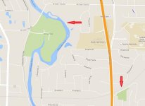
This is how Google maps normally shows parks, filled with green. This also applies to cemeteries and sometimes other select sites. As you zoom in, the name will appear. Zoomed too far out for the name, it is still green.
51740


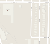
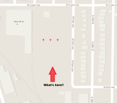
This is one of several locations I found recently. As you notice, there is a big blank spot. Not green, no information-even zoomed to maximum size.
51738


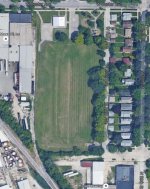
Here is the same location on Google Earth. Sort of looks like a park, doesn't it?
51739


I was able to track down the name of the park and found this map clip on Facebook. But even this map is incorrect as it shows the industrial site on the West side as park also!
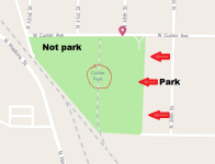
51741

Doing a bit more looking, I now realize this is not an isolated case. I found 2 more parks just like this in a rather small geographical are and I am positive there must be a LOT more to be found. I expect that non-locals who don't know of the existence of these "hidden" locations won't make a detecting trip here. So I think if some of these locations can be found in your detecting area, they may be untapped sources of land!

Tony Two-Cent
12-02-2015, 08:26 AM
I have noticed these anomalies as well, and have used them to my advantage. I love finding parks that don't show up as green on Google maps. I look at the satellite view of all surrounding towns, looking for the tell-tale signs of parks such as basketball courts, playground equipment, etc.

I have done very well at some of these parks. :yes:

Digger Don
12-02-2015, 08:54 AM
I have noticed these anomalies as well, and have used them to my advantage. I love finding parks that don't show up as green on Google maps. I look at the satellite view of all surrounding towns, looking for the tell-tale signs of parks such as basketball courts, playground equipment, etc.

I have done very well at some of these parks. :yes:

That's an understatement. LOL

GA1dad
12-02-2015, 02:46 PM
Thanks for the thread. I've used satelitte imagery a little bit,, but it's been a while. Your thread prompted me to piddle with it some more. As a result, I just found a "new" park that was recently built on top of 4 home sites. It's not a real old neighborhood, but old enough to have some silver. Thanks for the reminder.

Digger_O'Dell
12-02-2015, 08:03 PM
Glad I could provide some information! I found this also applies to certain abandoned cemeteries too, which often had the church that was in charge of it still in existence or at least the location on record.

I just spent 2 days at one of these "hidden" parks where I could trace the land back to the owner who was a Lt. Col. in the Civil War and willed it to the county as a park to bear his name. Unfortunately even though the park shows no real visible change since a 1937 aerial photo, nothing was found but about $1 in clad and lots of ghetto type trash. Nothing shows up more than maybe 2-4" deep, so must have been pounded really hard before the area got too bad.

GA1dad
12-02-2015, 11:15 PM
I went by the new park today after work. Took 5 minutes and dug 4 high 70's target,, two were clad coins. My first impression was that it hadn't been hit,,, at least not hard. When I got home I did some more research and was surprised to find it was a field in 1947 per the aerial. My thinking now is that there won't be much more than clad there. But I will go back when I have more time.

Digger_O'Dell
12-03-2015, 12:35 AM
I went by the new park today after work. Took 5 minutes and dug 4 high 70's target,, two were clad coins. My first impression was that it hadn't been hit,,, at least not hard. When I got home I did some more research and was surprised to find it was a field in 1947 per the aerial. My thinking now is that there won't be much more than clad there. But I will go back when I have more time.

Often you can also research a particular park and find out when it was opened. Though you are probably right that there will likely only be clad coins, there is very good potential to also find a lot more goodies such as lost jewelry if the park hasn't been pounded before. Also remember there is also the possibility there could still be items left from when it was a working field in the years before it became a park depending how much terraforming was done. Good luck to you!

Digger Don
12-03-2015, 09:08 AM
on my google earth, it does show up as Custer Playfield.
maybe different versions show differently.
Do you have places checked off on your layers?

Digger_O'Dell
12-04-2015, 12:01 AM
on my google earth, it does show up as Custer Playfield.
maybe different versions show differently.
Do you have places checked off on your layers?

Nope, nothing checked off on any layers. Maybe it's an anomaly when using Chrome browser? I don't know. The version of Explorer we use at work is old and no longer compatible with some features. But even on my phone, it doesn't work with the latest and greatest Android version. Maybe you just have the "special" computer with extra green ink? :rofl:

DIGGER27
12-07-2015, 08:06 AM
I always double check with bing maps because of this problem.
Not common but it does happen.
Also bird's eye view gives the most detail on closeups.

MangoAve
12-07-2015, 10:43 AM
I find it best to switch between mapping tools. Sometimes I can see the stone walls in the bird's eye that I can't in the satellite view. Sometimes I can't see the cellars in the bird's eye, but can in the Satellite due to the time of year the image was taken. Some have street view, some don't.

I have noticed a lot of errors in Google. Sometimes it's best for me to use my GIS mapping that I found. It seems to color the parks green, like google, but I'd trust the assessor more accurately. I've showed on here once about how the google parcel indicator lines (altho not always present in each town) are correct to the shape of the old map road lines. The only thing is that they are offset by a tad. I think it has something to do with the 1934 aerials coming from a plane, and you can see the points where the images meet. Google map has some sort of algorithm to adjust to the Earth's curvature while the 2D image does not. My GIS tool, tho, shows the roads that no longer exist. Well, I got three GIS tools depending on the area to hunt. But Imma look more into private spots after the luck I been having in comparison to the cellars I been finding.